Arctic Blast Continues with Freezing Rain/Ice, Then Back to Normal for Texas
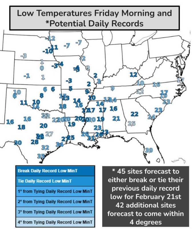
A bone-chilling Arctic blast continues to grip Texas, bringing a prolonged period of frigid temperatures and the potential for ice and freezing rain. This deep freeze rivals some of the most intense winter weather events in recent years, with some areas facing a multi-day stretch below freezing – a true test of winter resilience, especially for North Texas. The northern third of the state, including North Texas, remains locked in sub-freezing temperatures today, and tonight, nearly all of Texas will experience a hard freeze, excluding only the southernmost tip of the Rio Grande Plains and Valley.
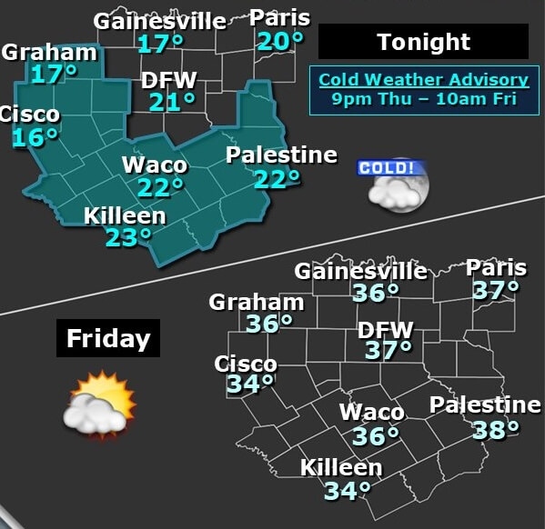
Prepare for the continued impact of this polar vortex and take necessary precautions against the bitter cold. While a gradual warming trend is expected tomorrow, a brief respite from the frigid air, temperatures will plummet again Friday night, leaving some communities, particularly in North Texas, to endure a third consecutive day of sub-freezing conditions. This prolonged freeze significantly elevates the risk of frozen pipes bursting as they thaw, especially those exposed in exterior walls. Monitor your plumbing closely for signs of damage.
Rainfall is expected from Friday afternoon through Saturday afternoon across the Brazos Valley, Rio Grande Valley, Rio Grande Plains, Coastal Bend, Coastal Plains, and the Golden Triangle. Fortunately, temperatures in these regions are generally forecast to remain above freezing, minimizing the threat of widespread icing. However, isolated freezing drizzle or light freezing rain could develop tonight in parts of South-Central Texas, though any ice accumulation is expected to be minimal. North Texas will likely remain dry during this period.
The situation becomes more complex late Friday afternoon and Saturday morning for South-Central Texas, Central Texas, and the Hill Country. Forecast models indicate an increasing probability of freezing drizzle and light freezing rain, potentially impacting areas from Austin to San Antonio and the surrounding Hill Country. With temperatures hovering precariously between 28 and 33 degrees, the risk of light ice accumulation is a concern, creating potentially treacherous conditions on bridges, overpasses, and highway ramps. This hazard could extend to surface roads, particularly those already cold-soaked from the extended freeze. This icy threat is reminiscent of past winter storms that crippled travel across the region. We are closely monitoring the situation and will provide updates as new information becomes available. Be prepared for possible travel disruptions in these areas late Friday and into Saturday morning. North Texas, however, is expected to avoid these icy conditions.
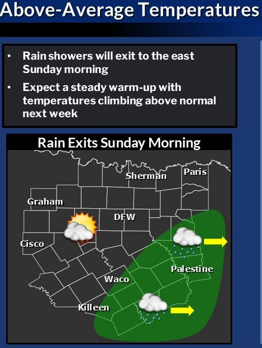
By Saturday, heavier showers and perhaps even a few thunderstorms are anticipated in East Texas, Southeast Texas, and the Golden Triangle. While severe weather is not expected, rainfall totals could reach up to one and a half inches, potentially causing isolated flooding. The rain will gradually taper off from west to east by Saturday evening. Rain showers will exit the region Sunday morning, leaving dry conditions over North and Central Texas through at least midweek next week. Looking ahead to the end of February and into early March, a significant warm-up is on the horizon for North Texas, with temperatures forecast to climb into the 70s by Monday, remaining above-normal through much of next week. This extended period of milder weather will be a welcome change after the current arctic blast, offering a chance to thaw out and recover from the prolonged freeze, particularly in North Texas. Longer-range forecasts suggest this trend of above-average temperatures will likely continue into early March, with potential for some spring-like weather. Stay tuned for updates as we move further into the new month.
Take a look at the Future 6 1o 10 Day Temperature Forecast for Texas
